


The Hauraki Plains are a geographical feature and non-administrative area located in the northern North Island of New Zealand, at the lower (northern) end of the Thames Valley. They are located 75 kilometres south-east of Auckland, at the foot of the Coromandel Peninsula and occupy the southern portion of a rift valley bounded on the north-west by the Hunua Ranges, to the east by the Coromandel and Kaimai Ranges and the west by a series of undulating hills which separate the plains from the much larger plains of the Waikato River. Broadly, the northern and southern parts of the Hauraki Plains are administered by the Hauraki District and the Matamata-Piako District respectively.The alluvial plains have been built up by sediment deposited by the Piako and Waihou Rivers, which flow north to reach the sea at the Firth of Thames, and earlier by the ancestral Waikato River. The resulting land is flat, peat-heavy, and partly swampy which has been converted into excellent land for dairy farming.Economically, the dairy farming is the leading primary industry, supported by other grassland farming. More recently, tourism in the Hauraki Plains region has been growing and the Hauraki Rail Trail, part of the New Zealand Cycle Trail, has been constructed in the Hauraki Plains.
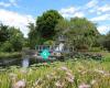 Ngatea Water Gardens
919 meter
Beautiful. Well kept and plenty of attractions inside. This place ought to be visite...
Ngatea Water Gardens
919 meter
Beautiful. Well kept and plenty of attractions inside. This place ought to be visite... Hauraki Plains
4 km
The Hauraki Plains are a geographical feature and non-administrative area located in ... Hauraki Plains
4 km
Die Hauraki Plains sind eine Ebene auf der Nordinsel Neuseelands.GeografieSie liegen ... Llanuras Hauraki
4 km
Las llanuras Hauraki son un área localizada en el norte de la Isla Norte de Nueva Zel...
Hauraki Plains
4 km
The Hauraki Plains are a geographical feature and non-administrative area located in ... Hauraki Plains
4 km
Die Hauraki Plains sind eine Ebene auf der Nordinsel Neuseelands.GeografieSie liegen ... Llanuras Hauraki
4 km
Las llanuras Hauraki son un área localizada en el norte de la Isla Norte de Nueva Zel...to add Piako Swamp map to your website;

