


El Parque nacional del Paso de Arthur se encuentra en la Isla Sur de Nueva Zelanda.Fue establecido en 1929, convirtiéndose en el primer parque nacional en la Isla Sur y el tercero en Nueva Zelanda. Es atravesada por la carretera estatal 73. El camino pasa por el pueblo del Paso de Arturo (Arthur's Pass) y el paso de montaña con el mismo nombre en los Alpes del sur a una altura de 920 metros sobre el nivel del mar. El parque es administrado por el Departamento de Conservación y opera un centro de depósito, administración e información en el pueblo de Arthur's Pass.Véase tambiénGeografía de Nueva ZelandaGeografía de OceaníaPasos de montaña más altos del mundo
 Arthur's Pass National Park
0 meter
Arthur's Pass National Park is located in the South Island of New Zealand.It was esta... Nationaal park Arthur's Pass
0 meter
Het 1170 km² grote Nationaal park Arthur's Pass is het op vijf na grootste nationaal ... Parc national d'Arthur's Pass
0 meter
A great drive up to the village with wonderful views. Great food at cafe and incredib... 亚瑟隘口国家公园
0 meter
A great drive up to the village with wonderful views. Great food at cafe and incredib... Arthur's Pass nationalpark
0 meter
The best way to start 2022. We covered most of the tracks around Arthur's pass. Defin... アーサーズ・パス国立公園
0 meter
A great drive up to the village with wonderful views. Great food at cafe and incredib... 아서스 패스 국립공원
0 meter
The best way to start 2022. We covered most of the tracks around Arthur's pass. Defin... הפארק הלאומי ארתור'ס פאס
0 meter
A great drive up to the village with wonderful views. Great food at cafe and incredib...
Arthur's Pass National Park
0 meter
Arthur's Pass National Park is located in the South Island of New Zealand.It was esta... Nationaal park Arthur's Pass
0 meter
Het 1170 km² grote Nationaal park Arthur's Pass is het op vijf na grootste nationaal ... Parc national d'Arthur's Pass
0 meter
A great drive up to the village with wonderful views. Great food at cafe and incredib... 亚瑟隘口国家公园
0 meter
A great drive up to the village with wonderful views. Great food at cafe and incredib... Arthur's Pass nationalpark
0 meter
The best way to start 2022. We covered most of the tracks around Arthur's pass. Defin... アーサーズ・パス国立公園
0 meter
A great drive up to the village with wonderful views. Great food at cafe and incredib... 아서스 패스 국립공원
0 meter
The best way to start 2022. We covered most of the tracks around Arthur's pass. Defin... הפארק הלאומי ארתור'ס פאס
0 meter
A great drive up to the village with wonderful views. Great food at cafe and incredib...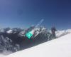 New Zealand Snow Safety Institute - NZSSI
835 meter
The NZSSI offers professional courses in mountaineering, back-country skiing, avalanc...
New Zealand Snow Safety Institute - NZSSI
835 meter
The NZSSI offers professional courses in mountaineering, back-country skiing, avalanc...to add Parque nacional del Paso de Arthur map to your website;

